Our work
Mapping Britain’s Climate Future
Ordnance Survey has been the definitive authority on mapping and geospatial data in Great Britain since 1791. Yet in a world of real-time data, satellite imagery and AI-driven analytics, the challenge is to demonstrate how OS continues to evolve and innovate, bringing the same authority it has always held to the most pressing challenges Britain faces today. With the most accurate, comprehensive and continuously updated geospatial dataset in the UK, OS remains the gold standard for location intelligence.
In 2025, OS appointed Diffusion to do exactly that, building a campaign rooted in the power of its own data. The brief was clear: demonstrate that OS’s capabilities are as vital to Britain’s future as they have ever been to its past and essential in helping its commercial customers make informed business decisions.
Insight & Idea
OS believes helping the UK prepare and adapt to climate and environmental change is one of the most essential roles it can play in the decades ahead, with its geospatial datasets and analytical capabilities uniquely placed to help commercial clients identify both opportunities and environmental risks. Diffusion’s campaign needed to reflect that ambition.
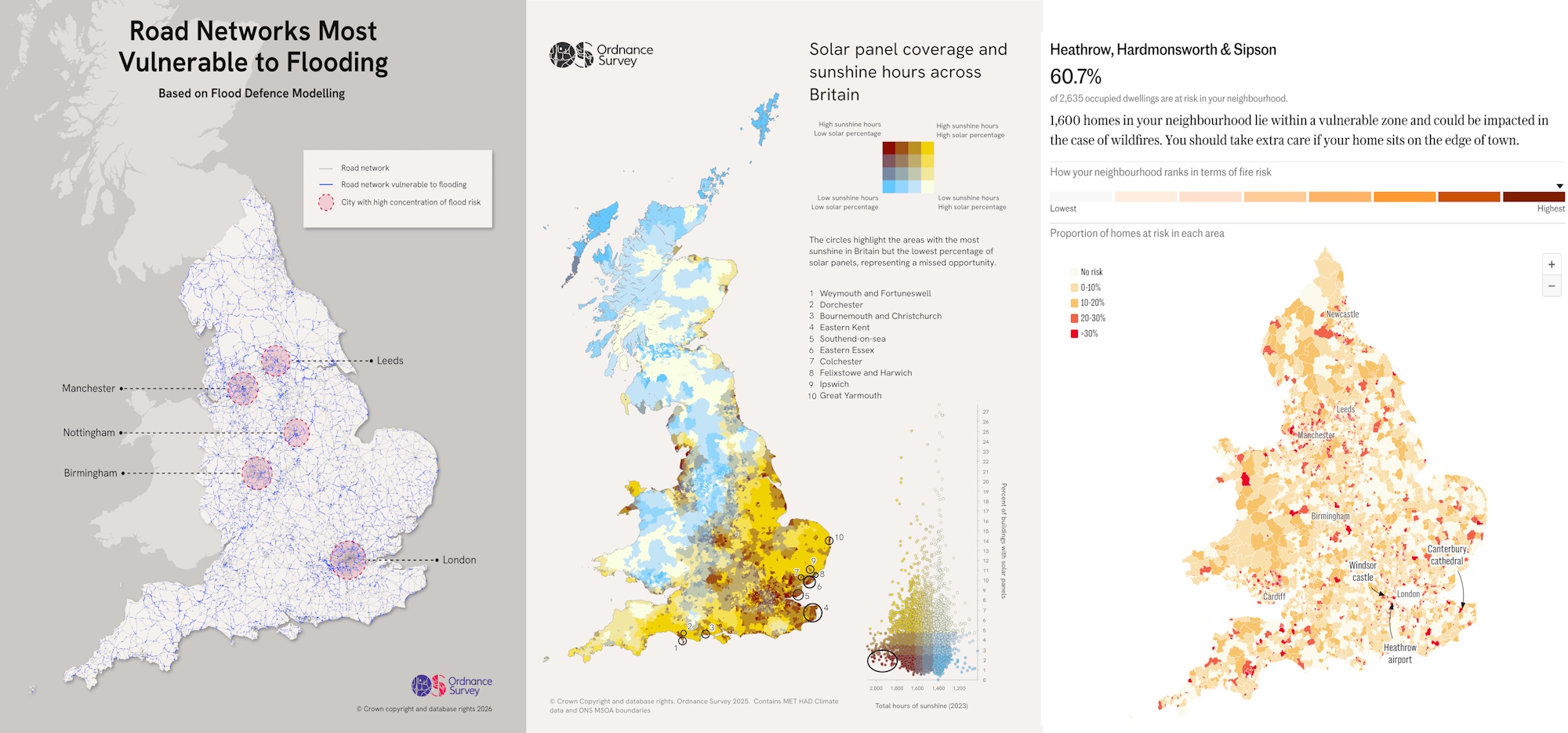
Working with OS’s data and industry sector teams, Diffusion identified four climate risk themes where OS had the ability to shine a new light using geospatial data: urban wildfire risk, solar energy potential, subsidence threats to residential buildings, and flooding vulnerability across Britain’s transport network.
For each, Diffusion matched the story to the right publications, packaged the data for accuracy and clarity, and where appropriate facilitated partnerships with complementary data providers including the British Geological Survey. OS sector experts were positioned as authoritative voices on these issues across mainstream media and key vertical trade outlets covering financial services, utilities and transport.
Impact + Action
Each theme generated a hero piece of coverage in a publication chosen for its relevance to the audiences OS most needed to reach, supported by secondary coverage across national, trade and specialist media.
OS analysis of 1.8 million homes near the rural-urban boundary, the zone where most wildfires occur, was the first mapping exercise of its kind, running as an exclusive in The i Paper, with an interactive wildfire data tool developed with The Telegraph.
Working with the British Geological Survey, OS mapped future subsidence hotspots to 2030 and 2070, overlaying climate projections with building density data, positioning OS as an essential intelligence partner for insurers with leading industry outlet, Insurance Post.
Analysis of nearly 1.3 million buildings revealed the scale of Britain’s solar opportunity gap, showing how the country’s sunniest areas have the lowest rates of rooftop installation, was also placed in The i Paper.
Published in March 2026, Diffusion secured a major data journalism collaboration with the Financial Times to map flooding threats to England’s road and rail network, with OS data and commentary underpinning an interactive postcode-level tool reaching over 11 million monthly unique users.
To articulate the future vision for Ordnance Survey and discuss its latest financial results, Diffusion also secured a business profile feature for CEO Nick Bolton with the The Observer.
Metrics + Outcomes
The campaign has established OS in the eyes of national and trade media as the authoritative source of data-led insight on how the UK can adapt to climate change, with journalists now approaching OS directly with requests for commentary and analysis. For OS’s commercial clients, it has demonstrated the power of its datasets, the analytical capabilities of its teams, and its ability to turn complex geospatial data into actionable intelligence that organisations can use to assess risk and make confident business decisions.